The Most Beautiful Mountains to Visit in Each European Union Nation: A Traveler’s Guide
Embark on an unforgettable journey to discover the most beautiful mountains across the European Union. From the majestic peaks of the Alps to the unique volcanic landscapes of the Canary Islands, this guide provides descriptions, travel information, and accommodation tips for each noteworthy mountain destination within the EU. Plan your next adventure and explore the breathtaking beauty of Europe’s highlands.
Austria: Ötztal Alps (Ötztaler Alpen)
The Ötztal Alps stand as an imposing bastion of rock and ice in Tyrol, Austria. This extensive mountain range boasts some of the Eastern Alps’ highest peaks, including the majestic Wildspitze (over 3,700 meters). Sparkling glaciers like Rettenbachferner and Tiefenbachferner sculpt the landscape, offering unique summer skiing opportunities. Deep, lush valleys dotted with picturesque traditional villages such as Sölden and Obergurgl contrast with the rugged summits. This region is a haven for nature lovers and sports enthusiasts, offering an endless network of hiking trails (from gentle walks to challenging high-mountain routes), thrilling via ferratas, and adrenaline-pumping mountain biking trails. In winter, it transforms into a world-renowned ski resort, attracting enthusiasts from everywhere. The discovery of “Ötzi,” the Iceman, has added a unique historical and archaeological charm to this Alpine region.
How to Get There:
The nearest airports are Innsbruck (approximately a 1-hour drive) and Munich (approximately a 3-hour drive). From there, you can rent a car or use public transport (trains and buses) connecting to the main Ötztal valleys (Ötztal Bahnhof is the main train station).
Where to Stay:
Numerous hotels, apartments, and Alpine huts (berghütten) are scattered throughout the valleys (Sölden, Obergurgl, etc.). The huts offer a more immersive mountain experience.
Belgium: Signal de Botrange
In contrast to towering Alpine peaks, Signal de Botrange represents the highest point of a rolling, verdant landscape in the Ardennes region of eastern Belgium. Situated on the High Fens plateau (Hautes Fagnes), Signal de Botrange is more of a gentle hill than a traditional mountain. Its significance lies in its geographical importance and the surrounding environment. The High Fens are a vast area of moorland and peat bog, characterized by unique flora and fauna, with well-marked trails inviting peaceful walks and cycling excursions. The landscape offers a wild and remote atmosphere, especially on foggy days, and in winter can be covered in a blanket of snow, ideal for cross-country skiing. The area is also steeped in history, having played a role during the World Wars.
How to Get There:
The nearest airports are Liège and Brussels. The area is accessible by car. There are also train connections to some nearby towns.
Where to Stay:
Hotels, bed and breakfasts, and holiday homes in the surrounding Ardennes villages (e.g., Malmedy, Eupen).
Bulgaria: Musala Peak (formerly Mount Botev)
Musala Peak, reaching 2,925 meters, is the highest summit of the majestic Rila Mountains, the highest mountain range in Bulgaria and the Balkan Peninsula. Its prominent position offers breathtaking 360-degree panoramas, extending to the Rhodope Mountains and beyond on clear days. The ascent of Musala is a rewarding experience for hikers, with trails passing through alpine meadows, glacial lakes, and rocky terrain. The mountain is part of the Rila National Park, known for its diverse flora and fauna, including endemic species. The Musala Meteorological Station is located near the summit. The hike can be challenging due to altitude and trail length, but the views from the top are well worth the effort.
How to Get There:
The main airport is Sofia. From there, you can reach the Borovets ski resort (the main starting point for the Musala hike) by bus or car (approximately 1.5-2 hours). A gondola lift from Borovets significantly reduces the initial ascent.
Where to Stay:
A range of hotels and guesthouses are available in Borovets. Mountain huts along the hiking trails offer basic accommodation (reservations are recommended).
Croatia: Velebit (Vaganski vrh)
The Velebit mountain range rises imposingly along Croatia’s Adriatic coast, separating the coastal strip from its hinterland. This long and rugged range features a spectacular karst landscape with rocky peaks, deep gorges, sinkholes, and caves. Vaganski vrh, at 1,757 meters, is one of its highest peaks. Paklenica National Park, situated in the southern part of Velebit, is famous for its impressive gorges (Velika and Mala Paklenica) and cliffs, attracting hikers and climbers worldwide. Velebit National Park is home to rich biodiversity, including endemic flora and fauna. Long-distance hiking trails, such as the Premužićeva staza, offer unforgettable experiences through wild and untouched landscapes.
How to Get There:
The nearest airports are Zadar, Split, and Rijeka. The Velebit range is accessible by car via various coastal and inland roads. For Paklenica National Park, the main entrance is near Starigrad-Paklenica, easily reached by bus from Zadar.
Where to Stay:
Hotels, apartments, and campsites are available along the Adriatic coast and in villages near the park (e.g., Starigrad-Paklenica). Mountain huts are located on the Velebit trails.
Cyprus: Troodos Mountains (Mount Olympus)
The Troodos Mountains form the backbone of the island of Cyprus, offering a refreshing contrast to the sunny coasts. This range is characterized by lush pine forests, verdant valleys, and picturesque villages nestled in the hills. Mount Olympus, at 1,952 meters, is the highest peak and offers panoramic views across the entire island. The Troodos region is rich in history and culture, with numerous Byzantine churches and monasteries adorned with frescoes, some of which are UNESCO World Heritage sites. Well-maintained nature trails invite pleasant walks and hikes, allowing you to discover hidden waterfalls and pristine natural corners. In winter, the slopes of Mount Olympus transform into a small ski resort, offering a unique experience of skiing with sea views.
How to Get There:
The main airports are Larnaca and Paphos (a 1-2 hour drive to the Troodos). Bus services connect the main Troodos villages.
Where to Stay:
Mountain hotels, agrotourism accommodations, and holiday homes in the Troodos villages (e.g., Platres, Kakopetria).
Finland: Halti
Halti, reaching 1,324 meters, is the highest point in Finland, situated in the remote and wild Lapland region, bordering Norway. This subarctic landscape is characterized by vast tundras, sparkling lakes, and dwarf birch forests. The Halti area offers an untouched wilderness experience, with long daylight hours during summer and the Northern Lights dancing in the sky during the long winter. Hiking in summer requires good preparation due to variable weather conditions and the area’s isolation. Winter activities include cross-country skiing, snowshoeing, and snowmobile excursions. The feeling of being in such a wild and remote environment is one of Halti’s distinctive features.
How to Get There:
The nearest airport is Kittilä (several hours by car/bus/snowmobile).
Where to Stay:
Spartan wilderness huts along the trails (inquire and book in advance). More equipped hotels and cottages in more distant villages.
France: Mont Blanc
Mont Blanc, soaring to 4,808 meters, is the highest peak in Western Europe and one of the world’s most iconic mountains. Its massif, with its permanent snow-capped peaks, imposing glaciers, and sharp ridges, dominates the Alpine landscape between France, Italy, and Switzerland. Chamonix-Mont-Blanc, at its base, is a legendary mountaineering capital. The region offers opportunities for all levels of mountaineering, from easy hikes on well-trodden paths to challenging high-altitude ascents with mountain guides. Cable cars, such as the Aiguille du Midi, allow access to spectacular viewpoints without long climbs. In winter, Mont Blanc transforms into a world-class skiing and snowboarding paradise, with renowned resorts like Les Grands Montets and the Vallée Blanche.
How to Get There:
The nearest airports are Geneva (a 1-hour drive) and Lyon (a 2-hour drive). Chamonix-Mont-Blanc is well-connected by highway and train.
Where to Stay:
A wide range of hotels, chalets, and apartments in Chamonix and the surrounding valleys. High-altitude Alpine huts for mountaineers.
Germany: Zugspitze
The Zugspitze, reaching 2,962 meters, is Germany’s highest mountain, located in the Bavarian Alps near the Austrian border. This iconic peak offers 360-degree panoramic views of the German, Austrian, Swiss, and Italian Alps. The summit is easily accessible via a cogwheel railway running through a tunnel inside the mountain and several cable cars. Panoramic restaurants, a weather station, and a small glacier (Schneeferner), where skiing is possible even in summer, are located at the top. Well-marked hiking trails lead to viewpoints and Alpine huts. In winter, the Zugspitze transforms into a popular ski resort. The combination of easy accessibility and breathtaking views makes it a year-round popular destination.
How to Get There:
The nearest airport is Munich (a 1.5-2 hour drive/train ride to Garmisch-Partenkirchen). Ascent via cogwheel railway or cable car.
Where to Stay:
Numerous hotels, guesthouses, and apartments in Garmisch-Partenkirchen and nearby villages. Option to stay in a hotel at the Zugspitze summit.
Greece: Mount Olympus
Mount Olympus, culminating at 2,917 meters with the Mytikas peak, is Greece’s highest mountain and a place steeped in history and mythology, considered the home of the ancient Greek gods. This imposing mountain massif features rugged peaks, deep gorges, and rich biodiversity, with forests of beech, pine, and fir giving way to alpine landscapes at higher elevations. The ascent to the summit requires good physical fitness, and reaching Mytikas involves a short scramble. Several well-marked trails traverse the mountain, offering routes of varying difficulty and allowing exploration of its natural beauty. Alpine huts along the trails provide refreshment and overnight stays. The view from the summit is spectacular, encompassing the Aegean Sea and the plains of Thessaly.
How to Get There:
The nearest airport is Thessaloniki (a 2-hour drive to Litochoro). Buses run to Litochoro (the starting point for hikes).
Where to Stay:
Alpine huts along the trails (book in advance). Hotels and guesthouses in Litochoro and nearby villages.
Ireland: Carrauntoohil
Carrauntoohil, at 1,038 meters, is Ireland’s highest peak, situated in the wild and scenic MacGillycuddy’s Reeks range in County Kerry. This sharply pointed mountain rises above a landscape of glacial valleys, sparkling lakes, and moorland. The hike to the summit is challenging due to the often steep and rocky terrain, but the view from the summit cross is breathtaking, offering a 360-degree panorama of the Irish landscape, with the Atlantic coast in the distance. Mountain weather can change rapidly, so it’s essential to be well-prepared with appropriate clothing. The surrounding region is ideal for hiking and mountaineering, with numerous other peaks and trails to explore.
How to Get There:
The nearest airports are Cork or Shannon. Killarney is reachable by bus/train (drive to Carrauntoohil).
Where to Stay:
A wide selection of hotels, bed and breakfasts, and hostels in Killarney and the surrounding areas.
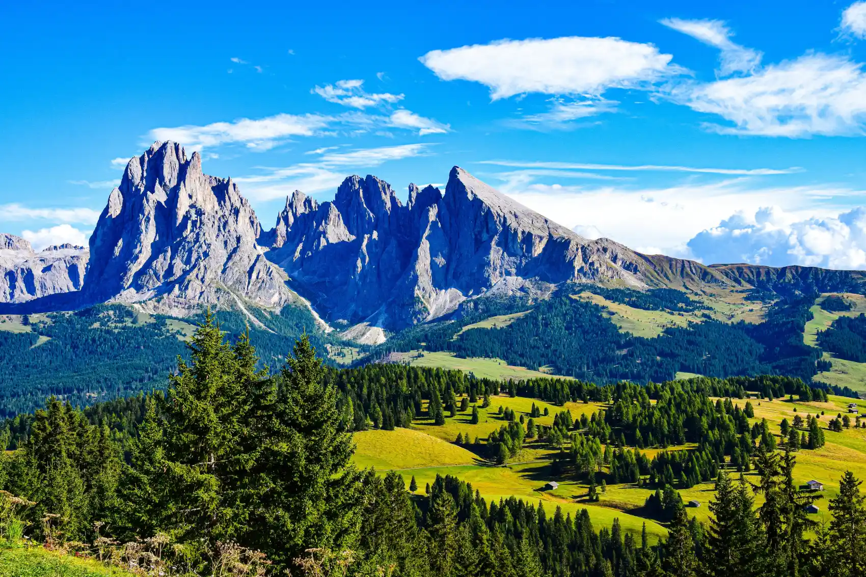
Italy: Dolomites (Dolomiti)
The most beautiful mountains in the world
The Dolomites, a UNESCO World Heritage site, are a unique mountain range characterized by jagged limestone peaks, vertical walls, slender towers, and picturesque valleys. Their summits, often taking on pink and orange hues at sunset (the Enrosadira phenomenon), create an unforgettable natural spectacle. This region offers an endless variety of outdoor activities, from hiking on well-marked trails to thrilling via ferratas, from sport climbing to high-altitude mountaineering. In winter, the Dolomites transform into one of the largest and most beautiful ski resorts in the world. Each Dolomite valley (Val Gardena, Cortina d’Ampezzo, Val di Fassa, etc.) has its own cultural and landscape identity, offering a blend of natural beauty and local traditions.
How to Get There:
The nearest airports are Venice, Verona, Innsbruck, or Munich (depending on the area). Well-connected by scenic roads and buses.
Where to Stay:
A vast range of hotels, apartments, Alpine huts (rifugi), and campsites throughout the Dolomite valleys.
Poland: Tatra Mountains (Rysy)
The Tatra Mountains, the highest range of the Carpathian Mountains, form a natural border between Poland and Slovakia. The Polish side offers grand alpine landscapes with high peaks, crystal-clear mountain lakes like the famous Morskie Oko (Eye of the Sea), and deep valleys. Rysy, at 2,501 meters (the highest peak on the Polish side), offers a spectacular panoramic view of both the Polish and Slovak Tatras. Hiking trails are well-maintained and vary in difficulty, attracting both casual hikers and experienced mountaineers. Zakopane, at the foot of the Polish Tatras, is a vibrant tourist town with a rich folk culture, traditional wooden architecture, and a unique mountain atmosphere.
How to Get There:
The nearest airport is Krakow (bus/train to Zakopane).
Where to Stay:
Numerous hotels, guesthouses, apartments, and mountain huts (schronisko) in Zakopane and along the trails.
Portugal: Serra da Estrela (Torre)
Serra da Estrela is the highest mountain range in mainland Portugal, characterized by unique landscapes within the Portuguese context. Its rounded peaks and glacial valleys offer a contrast to the surrounding plains. Torre, the highest point at 1,993 meters, is unusually accessible by road and hosts infrastructure such as an astronomical observatory and some limited winter ski facilities. The region is famous for its mountain pastures, where prized sheep breeds and the renowned Serra da Estrela cheese are produced. Hiking trails traverse landscapes of moorland, mountain lakes, and traditional villages, offering a mountain experience different from the rest of Southern Europe.
How to Get There:
The nearest airports are Lisbon or Porto (car/bus). Torre is accessible by car.
Where to Stay:
Mountain hotels, pousadas (historic hotels), and rural guesthouses in the villages of Serra da Estrela.
Slovakia: High Tatras (Gerlachovský štít)
The High Tatras, the highest part of the Tatra Mountains, stand majestically in northern Slovakia, offering alpine landscapes of rare beauty. Imposing peaks exceeding 2,600 meters (including Gerlachovský štít, the highest at 2,655 meters), sparkling glacial lakes (such as Štrbské Pleso and Skalnaté Pleso), and deep valleys characterize this landscape. Hiking is a very popular activity, with well-marked trails leading to mountain huts (chaty) and spectacular viewpoints. The ascent of Gerlachovský štít is technically challenging and permitted only with licensed mountain guides due to the lack of marked trails in some sections and potential hazards. The resorts of Tatranská Lomnica and Štrbské Pleso are important tourist centers with excellent infrastructure.
How to Get There:
The nearest airport is Poprad-Tatry, at the foot of the High Tatras. The region is well-connected by train and bus. Ascent of Gerlachovský štít is only with a guide.
Where to Stay:
A wide selection of hotels, pensions, apartments, and mountain huts (chaty) in the tourist resorts (Tatranská Lomnica, Štrbské Pleso).
Slovenia: Julian Alps (Mount Triglav)
Mount Triglav, at 2,864 meters, is not only Slovenia’s highest peak but also a national symbol deeply rooted in the country’s culture and history. Situated in the heart of Triglav National Park in the Julian Alps, this distinctively shaped mountain (with three peaks) dominates the surrounding landscape. The ascent of Triglav is a popular undertaking among Slovenians and is often considered a rite of passage. The classic route involves using via ferratas (trails equipped with metal cables and ladders) to overcome the more exposed sections. Alpine huts (koče) along the route offer essential shelter and are crucial stops for multi-day hikes. The view from the summit encompasses the Julian Alps and the Slovenian landscape as far as the Adriatic Sea on clear days.
How to Get There:
The nearest airport is Ljubljana (a 1-2 hour drive/bus ride to Triglav National Park).
Where to Stay:
Alpine huts (koče) within the park (book well in advance). Hotels, apartments, and campsites in the surrounding villages (e.g., Bled, Bohinj).
Spain: Teide (Tenerife, Canary Islands)
Mount Teide, standing majestically at 3,715 meters on the island of Tenerife, is Spain’s highest mountain and an active (though dormant) volcano. Its unique volcanic landscape, with craters, lava flows, and colorful rock formations, resembles lunar scenery. Teide National Park, a UNESCO World Heritage site, is home to endemic flora and fauna adapted to these extreme conditions. The ascent to the summit can be done on foot (with a special permit required for the final section) or more easily by cable car, which offers spectacular views during the ride. From the summit, the panoramic views of Tenerife and the Atlantic Ocean are breathtaking. Stargazing is another popular activity due to the altitude and clear skies.
How to Get There:
Tenerife has two international airports (North and South). Teide National Park is easily accessible by car or bus from the main tourist resorts on the island. Ascent by cable car (permit needed for the very top).
Where to Stay:
A vast array of hotels, resorts, and apartments in the coastal areas of Tenerife (Los Cristianos, Playa de las Américas, Puerto de la Cruz). Option to stay in the Altavista Refuge near the summit (requires booking).